Is the underwater waterfall in Mauritius real?
Real or fake, in one paragraph
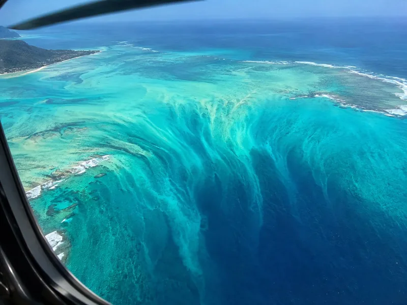
The photographs are not doctored. If you fly the loop from the airport helipad you will look down at the tip of Le Morne and see what the pictures show: a wide, pale tongue of sand that appears to pour over an edge into deep blue and vanish. What the pictures cannot tell you is that nothing is falling. The colour change is the seabed dropping away, and the streaks are sand settling down that slope. I grew up three kilometres north of it in La Gaulette and my grandmother called it la rivière en bas la mer, the river under the sea, which is closer to the truth than “waterfall”. It is a river of sand, and it moves at the pace sand moves.
How it happens
Mauritius sits on a submarine shelf that is nowhere deeper than about 150 m. Around most of the island the reef sits on that shelf and the lagoon inside it is a few metres deep. At the south-west tip, off the Le Morne peninsula, the shelf ends abruptly and the seabed drops to more than 4,000 m. Currents running along the shelf pick up sand and silt from the lagoon floor and carry it over the edge. The sand then slides down the slope, and while it is doing that it hangs in the water as a plume. Shallow water over pale sand reads as pale blue from the air; deep water reads as near-black. Where the plume crosses from one to the other you get the shape of a waterfall.
That is the whole mechanism. There is no cave, no hole, no vertical shaft. The “bottom” that people ask about is a long sand slope, which I go into on how deep the underwater waterfall is. A rougher explanation of the geology and of what each way of seeing it really shows is in the complete guide.
Why the photos look like a waterfall
Height and angle. From a boat you are looking across the surface and you see a normal lagoon edge with a darker band beyond it. From a few hundred metres up, looking down at a slant, the brain does what it does with any pale shape running into a dark one with a hard edge: it reads a river and a cliff. Add the fact that the sand plume genuinely has streaks in it, like water braiding over rock, and the illusion is complete. It is strongest when the sun is high, roughly 10:00 to 14:00, and the sea is calm and clear. After heavy rain or a big south-westerly swell the plume is muddier and the contrast drops. I set out the seasons and the light on the best time to see it.
What it is not
- Not moving water. The sea surface over it is flat and the swell runs through it unchanged.
- Not a vertical drop. The sand goes down a slope, not over a lip.
- Not something you can swim to, snorkel over or dive on. There is nothing to arrive at, and the plume is off the reef in open water. More on whether it is safe.
- Not visible from the beach, a boat or a catamaran. From the summit of Le Morne Brabant on a calm clear day you can make out its rough shape, and no more.
- Not the largest underwater waterfall in the world. That is the Denmark Strait cataract, which is real cold water dropping about 3,500 m; see the world’s largest underwater waterfall.
So how do you see it?
From the air, and in practice that means a helicopter. Two of the three helicopter products sold on GetYourGuide fly a loop built around the pass over Le Morne; the seaplane sold there flies the north-east coast from Grand Gaube and does not overfly it. The four ways, ranked, are on how to see the underwater waterfall.
If someone tells you they saw the underwater waterfall from a boat, they saw the reef edge. The illusion needs height. The lowest I have seen it work from is the summit of Le Morne Brabant at 556 m, and even there it is a shape, not a picture.
Check dates on the flight built around it
The 40-minute flight from the airport helipad routes over Grand Bassin and the Black River Gorges to the west coast, makes its pass off Le Morne, then comes home over Chamarel.
Frequently asked questions
Is the underwater waterfall real or fake?
Real place, fake waterfall. The photographs are genuine and the effect is visible from every helicopter that passes off Le Morne, but no water is falling. Sand and silt slide off a shelf about 150 m deep into a drop-off of more than 4,000 m, and from the air the plume looks like a river over a cliff.
How does an underwater waterfall happen?
Currents carry sand off the edge of the shallow shelf around Mauritius and down the slope of the drop-off. Pale sand over shallow water next to near-black deep water gives the outline of a waterfall when you look at it from above. The depth figures are on how deep the underwater waterfall is.
Can you visit the underwater waterfall?
You can fly over it. You cannot stand at it, swim in it or dive it, because there is nothing there but a sand slope in open water off the reef. The flights that pass over it are compared on how to see the underwater waterfall.
Is water actually flowing to the bottom of the sea?
No. The sea surface is flat and the water column is the same water it always was. The only thing moving downhill is sand, and it settles on the slope rather than reaching any bottom.
Which country is the underwater waterfall in?
Mauritius, in the Indian Ocean, about 2,000 km off the south-east coast of Africa. It is off the Le Morne peninsula in the Black River district; the coordinates and distances are on where the underwater waterfall is.